 |
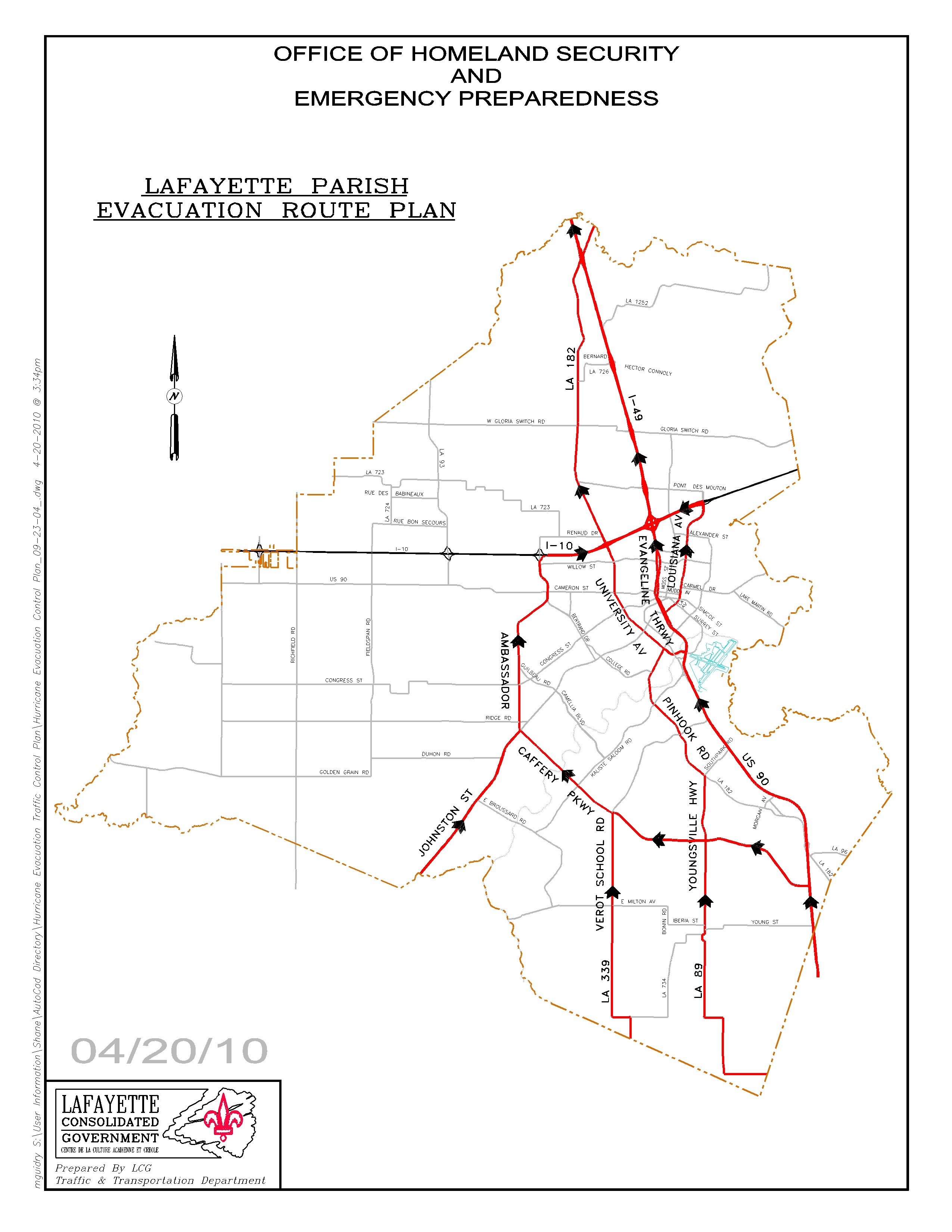
Lafayette Hurricane
Evacuation Routes
|
 |
This information applies only to the pre-planned hurricane evacuation
routes through
Lafayette Parish.
For other types of evacuations please follow the instructions
provided through the news media.
The routes described are the major south to north routes
through Lafayette Parish.
If you need to know which routes are planned for the following
areas, just click on the name.
ABBEVILLE
BALDWIN
BROUSSARD
CARENCRO
DUSON
ERATH
FRANKLIN
JENNERETTE
MILTON
MORGAN CITY
NEW IBERIA
PATTERSON
SCOTT
YOUNGSVILLE
All north bound traffic leaves Lafayette Parish on
I-49 NORTH.
-
If you are leaving from South of I-10,
use Ambassador Caffery Pkwy (and then I-10 EAST)
or Evangeline Thruway
to join I-49 NORTH.
-
If you are leaving from North of I-10,
join I-49 NORTH
and
continue north on I-49 towards Alexandria and points north.
Traveling north on US 90 from New Iberia, when you get to Ambassador Caffery Parkway
(LA 3073), you have the option of either turning left onto Ambassador Caffery
Parkway and following it, or continuing straight ahead on US 90 continuing north
past Broussard. The name of this portion of US 90 within the City of Lafayette
is Evangeline Thruway. When you get to University Ave (by the Lafayette Regional
Airport), you have the option of either turning left onto University Ave and following
it north, or continuing north on the Evangeline Thruway. If you turn left onto
University Ave, follow it north through Carencro until you merge with I-49 and
then continue north on I-49. If you opt not to turn, continue north on Evangeline
Thruway. When you get to the intersection of the Evangeline Thruway and Louisiana
Avenue, you have the option of either turning right onto Louisiana Avenue, or
continuing North on the Evangeline Thruway. If you turn right onto Louisiana Avenue,
follow it until you get to I-10. Turn left (west) onto I-10 and then right (north)
onto I-49 towards Opelousas. If you opt not to turn, continue North on the Evangeline
Thruway towards Opelousas. US 90 will leave the evacuation route at Mudd Avenue;
do not turn there. This route will pass under I-10 and the name of Evangeline
Thruway will change to I-49. Continue north on I-49 towards Alexandria and points
north.
Traveling north on LA 89, the route goes through Youngsville. The route continues
to Pinhook Road (LA182). Turn left on Pinhook Road and follow it to University
Avenue. Turn left on University Avenue and follow it north to I-10. At I-10, you
have the option of either turning right (east) on I-10 to go over to I-49 and
then turn north on I-49, or continuing north on University Avenue (LA182) through
the City of Carencro until you get to I-49 and then go north on I-49. Continue
north on I-49 towards Alexandria and points north.
Traveling north on LA 339 from Erath, cross LA 92.
LA 339 is called Verot School Road in Lafayette Parish.
About 2.2 miles north of LA 92,
there is a major intersection.
Turn left there onto Ambassador Caffery Parkway (LA 3073).
Continue north on Ambassador Caffery Pkwy. until it intersects with I-10.
Join
I-10 EAST
for about 3 miles.
Exit I-10 EAST at Exit 103B onto
I-49 NORTH.
Continue north on I-49 towards Alexandria and points north.
Traveling north on US 167 from Abbeville, cross LA 733 (E. Broussard Rd.).
About 2.2 miles after crossing LA 733 there is a major intersection. Turn left
there onto Ambassador Caffery Pwky (LA 3073). Continue north on Ambassador Caffery
Pkwy. until it intersects with I-10. Join I-10 EAST for about
3 miles. Exit I-10 EAST at Exit 103B onto
I-49 NORTH. Continue north on I-49 towards Alexandria and points
north.
Lafayette Parish Evacuation Route Map

Click Here for a Larger Map
Lafayette Parish Area Map


