|
|
||||||||||||||||||||||||||||||||
|
Proyecto Alto Purús: Geographic and Taxonomic Scope
|
||||||||||||||||||||||||||||||||
|
The Alto Purús lies within the Southwestern Amazon Moist Forests ecoregion, the largest remaining wilderness area in the Amazon and one of the World's top conservation priorities (Brunckhorst 2000). As is the case with many freshwater ecosystems throughout South America, the aquatic fauna of the Alto Purús is, as yet, uncatalogued (Tovar 1998 ; INRENA 1999, 2001; Norgrove 2005; Patterson 2006). The Alto Purús was designated a Reserved Zone in 2000 and a Park in 2004 in the Departments of Madre de Dios and Ucayali (Norgrove 2005). Along with the adjacent Manu National Park (Manu) and nominally protected areas in Bolivia and Brazil, the Alto Purús forms the core of the largest conservation corridor in the Amazon Basin (Patterson 2006), in an area of exceptional species-richness and endemism (Kullander 1986; Nelson et al. 1990; Pacheco 1996. ; Kress et al. 1998; Peres 1999). As a protected area, the Alto Purús retains a relatively intact forest and aquatic ecosystem in comparison to unprotected sites closer to urban centers. The Alto Purús is similar to other semi-isolated foothill (piedmont) regions of the western Amazon in overall hydrology, geomorphology and vegetation (Pitman et al. 1999; Pitman et al. 2001, 2002; Leite-Pitman et al. 2003). Consequently, the products of this project are of interest and use to scientists and resource managers working in the Amazon Bolivia, Brazil, Colombia, Ecuador, Peruvian and Venezuela.
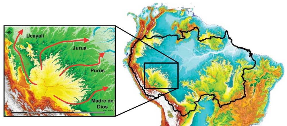
Geographical and climate data for the Alto Purús region are provided in (Leite-Pitman et al. 2003). The Andean foothills are more deeply dissected topographically than are Amazonian lowlands, and display a less extreme annual flood regime (2-5 vs. 8-10 m). The park is drained by four major Amazon tributaries. The Purús is the largest river in the park, flowing 483 kilometers ENE towards Brazil, and from 60-100 m across and 5-15 m deep in its lower reaches. The Curanja River (212 km) is the largest tributary of the Purús within the reserve. The Purús has sandy beds and mud/clay banks, and courses through stands of bamboo, varillals (white sand forests) and black water lagoons. The Las Piedras River drains the southern portions of the park where it is an affluent of the Madeira. The western and northern portions of the park drain to the Ucayali and Jurua basins, respectively. Within the park, water chemistry ranges from blackwater forest streams with acidic (pH = 3.5-5.5), low conductivity (20-40 µs/cm) and low sediment load water, to larger whitewater streams and rivers with higher sediment load, moderate acidity (pH = 5-6), and moderate conductivity (50-200 µs/cm). As in other areas of the Andean Piedmont, the park is characterized by two major landscape types; alluvial floodplains (~5% surface area) and upland tierra firme (~95% surface area). Alluvial floodplains and hydromorphic terraces are more extensive towards the park periphery. The Alto Purús is divided into four main forest types based on plant taxonomic composition and terrain; dense lowland forest, dense highland forest, dense hillside forest, hydrophytic palm forest. The Alto Purús includes all four principal Andean Piedmont soil types; the heavily leached alfisols and weathered ultisols of older stable tropical landscapes, and younger alluvial entisols and poorly developed inceptisols. The average annual temperature is approximately 25°C, with extremes of 17°C and 35°C depending on local conditions. Relative humidity averages between 75 to 82%. Rains last from November to March with an annual average of around 2.6 m. The taxonomic scope of this project focuses on a major subset of the aquatic fauna that can be thoroughly inventoried within the time and resources of a NSF grant. Multi-season high intensity sampling within one area is more cost-effective than a disparate, geographically expansive sampling. Moreover, this sampling regime is expected to reveal information on seasonal movements, breeding patterns and the general natural history of the fauna. The taxonomic scope also prioritizes taxa for which thorough species inventories and guides benefit a wide range of professionals (e.g., ecologists, resource managers, and biogeographers). Full species inventories are being compiled for the following taxa: macrocrustaceans, fishes, platyhelminths, mollusks, and sponges. The sampling design emphasizes macroinvertebrates which are ecologically important components of the fauna in most Neotropical aquatic systems (Jacobsen and Bojsen 2002; Pouilly et al. 2003; Eitam et al. 2004; Pouilly et al. 2004; Pouilly et al. 2006) and moist soils (Irmler 1975; Lavelle and Lapied 2003; Feigl et al. 2006) environmental settings.
|
||||||||||||||||||||||||||||||||
| Home | Research | Teaching | People | Publications | In the Lab | |||||||||||||||||||||||||||